Frederick Douglass Academy GIS Week Highlights
- Frank Romo

- Feb 2, 2024
- 5 min read
We had an exciting week of Geospatial Information Systems (GIS) events! We had the opportunity to celebrate the accomplishments of the Frederick Douglass Academy (FDA) GIS Pathways Program and to continue to share our impactful GIS applications contributing to the advancement of our communities and the geospatial industry. We took advantage of the annual celebration of GIS Day to engage with other GIS professionals and share the geospatial work of FDA students to raise awareness of the potential capabilities of the technology. Please see more of our GIS Week highlights below.
Day 1 - EOS On Campus Visit

Jean-Yves Lauture presenting/ introducing himself
Jean-Yves Lauture told us about himself and we learned that he manufactured the first GPS locator before the market was even ready for them. He gave us insight into GIS and GPS and said, "You guys got it easy now. When we wanted to use the internet we would have to go on the world wide web browser and request internet access before actually being able to get on. It will send to the satellite and it will come back to your computer once it has responded, sometimes it could be within a few minutes or hours, possibly days."
Interviews With EOS Staff

After the great presentation from Mr. Jean-Yves Lauture, we proceeded to do our interviews talking about our ArcGIS Pathways Program, our brotherhood, and what the school has done for us as students to prepare us for the real world. After we graduate from high school we believe we will be ahead of the game with our public speaking skills, ArcGIS skills, and skills with drones. This preparation will get us far in life because we will be leaving high school with these skills that people pursue in college due to the fact they didn't have a high school with a Pathways Program like how we got. The Pathways Program is preparing us for college and a job if college isn't the next step for us.

These interviews were really fun to do and we enjoyed speaking with Sarah Alban and Emma Hardy.
After the interviews, we learned how to use the GPS receiver and ran a simulation to pinpoint specific locations. We also got insight on some upcoming research EOS is working on using this tool. He told us how he used to make these and sell them on the market. He also showed us how he uses the GPS locator with Field Maps. We were familiar with Field Maps, so when he brought that up we got excited that we were already using tools that he uses with his GPS receiver.

GPS Receiver
Then, we started looking at the pictures our drones took to update them on the ArcGIS map of the school. We also had a presentation at Michigan State University coming up, so we started preparing for our GIS Day event by reviewing our slides making sure the grammar is correct and making sure our presentation isn't boring. To enhance our presentation, we had Ray Lillibridge help add our ArcGIS map version to our slides.

Day 2 - EOS Back on Campus

Michael Cousins presented to us a sketch of our whole school area telling us the problems with the water pipes underground, the air quality, and how he was able to obtain this information. He emphasized how important professional connections were with him being close to a team studying and monitoring this type of data. The team easily gives him data and information when he asks for the area.

GPS Receiver
Moving forward, Michael Cousins and Jean-Yves Lauture took us outside for an exciting drone activity. We recently marked chevrons around our school to do surveillance and programmed the drone to autonomously go to every chevron, take a picture and come back to us. During this activity, we were using the GPS receiver to mark locations using Field Maps to get the exact coordinates of the area. Mr. Cousins and Mr. Jean told us about how when the GPS locator is activated it sends a signal to the satellite and the satellite retrieves the approximate location of where the GPS Locator is. If you're logged in on a mobile device it will show the exact location of your phone. To make the location of the locator more accurate you would have to edit the SBAS, PDOD, and the H RMS; it will adjust to the satellite and give a better signal to make the location more accurate. We even tested this in two different locations so we could know how it worked.

FDA kids teaching Mr. Jean how to fly a drone
We began to fly drones around the school with EOS taking pictures of us with the drones. Emma and Zemarion went over how to work the camera. We even gave Mr. Jean his first experience of flying a drone! He was having fun and did not want to stop flying. We had a conversation with Sarah, Mr. Jean, and Emma about life, including their past experiences with GIS and college.
Day 3 - GIS Day at MSU
DeAnthony Neal started off the GIS Day event by presenting our GIS Pathway Programs at Michigan State University (MSU). He talked about how the program offers dual enrollment courses through Eastern Michigan University. DeAnthony explained when taking the dual enrollment courses you start from 9th grade then by the time you're a senior working through the pathway you'll have 9 transferable credits to almost all of the universities. He also talked about how our GIS Pathway Program is the first NAF distinguished school in Michigan and how that got us invited to a NAF conference in New York.
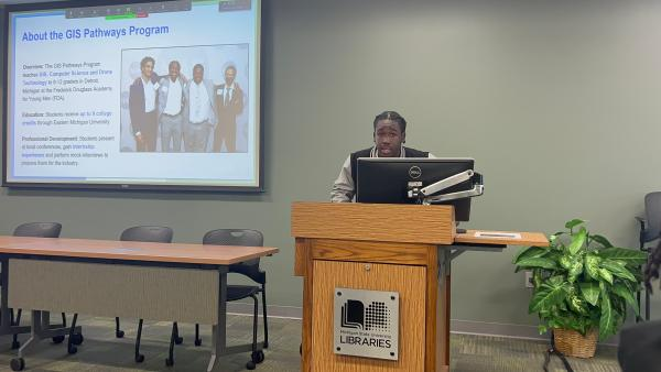
DeAnthony Neal Presenting About The GIS Pathways Program

FDA Student At GIS Day
During the other GIS Day events, our students were engaged and asked amazing questions about the presentations. During lunch break we exchanged business cards with people in the geospatial industry and this networking opportunity helped us gain as much as possible from the GIS Day event. We even learned that you can make your own Geospatial data or GIS service for other people to use or make your own maps on.

James Coleman And Kerry Hamilton Presenting
James Coleman and Kerry Hamilton 's presentation talked about our eyes in the sky. They explained that our eyes in the sky are chevrons marked around our school so the drone can spot it to take a picture. They shared how we set the drone autonomous to each chevron to take a picture of each area we marked. We collected this data so we can add it to our ArcGIS Map version of our school to have more updated photos than we had recently after our school switched buildings.
Then Benjamin Gavin , Ashton Colson , and Ray Lillibridge had the honor to speak on the Drone Panel. They shared their thoughts on disadvantages and advantages of the current drone technology. One of the big advantages of having drones is you can surveillance small compact area's better than a helicopter or plane would because a drone will get every inch of the perimeter. A disadvantage the drone panel spoke about was the restrictions in the airspace meaning there’s certain areas you cannot fly in because it's a controlled airspace.

FDA Talking On The Drone Panel at Michigan State University
Thank You

We are grateful to have collaborated with EOS to document the stories of impact from the GIS Pathways program, which will continue to promote GIS awareness and educational opportunities. We are also excited to have been invited to speak at Michigan State University for their official GIS Day event! Please continue to follow the progress of the GIS Pathways Program and support our efforts through the donation link on our website .

Thank to our sponsors that continue to support our GIS Pathways Program EOS , OHM Advisors , and RomoGIS.
Thank you to our Pathways Program Director Chad Segrist.
Thank you to our Photographers Jonathan Zook , Deandre Jones , Emma Hardy , and Sarah Alban.


Comments